Maps and Directions
Use the following links to find directions to your specific rafting trip meeting spot.
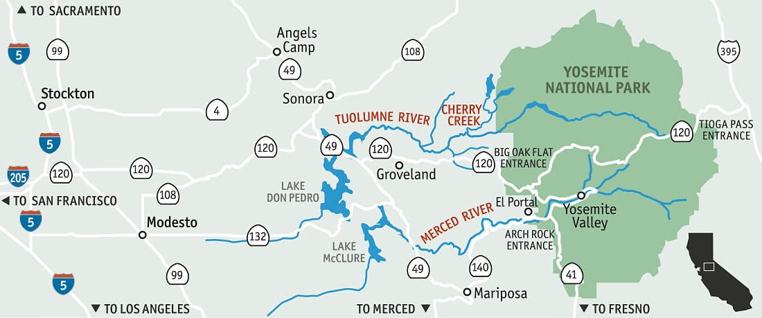
Sierra Main Tuolumne River rafting trips meet at Sierra Mac River Trips at Colfax Springs • 27890 CA-120, Groveland, CA 95321 at 8:30 am (unless otherwise scheduled), 7 mi. E of Groveland on CA Hwy 120.
Driving time to Groveland from the Bay Area is about 3-1/2 hours; from Manteca, about 1-1/2 hours; from Los Angeles, about 7 hours.
New 2019 Merced Rafting Meeting Spot. All trips now meet at the Merced Rafting Headquarters, 6940 State Highway 140, Midpines, CA, 95345. Our secure meeting spot is eight miles from Mariposa, and just across Highway 140 from the Yosemite Bug Rustic Mountain Resort.
Merced Full-day trips meet at 9:30 a.m. sharp! Morning Merced 1/2-day trips meet at 8:00 a.m. sharp! Afternoon Merced 1/2-day trips meet at 1:30 p.m. sharp!
Please note that the Highways in and around Yosemite can be confusing, and summer traffic can add driving time to the estimates below. It is important that you key into where you are staying, and are clear on your driving directions. It is your responsibility to get to our meeting spot in Midpines ON TIME. If you are late, you will miss your trip and sorry, but there are no refunds for missed trips!
From Yosemite Valley: Take the Highway 140 Exit out of Yosemite Valley heading west toward Mariposa and follow the Merced River downstream. Continue traveling west on Highway 140 towards Midpines. As you pass the turnoff for the Yosemite Bug Rustic Mountain Resort, begin looking for our signs. Our driveway is on the left-hand side of the highway, on the outskirts of the town of Midpines. Driving time from the Yosemite Valley floor is about 1 hour and 15 minutes to 1 hour and 30 minutes, depending on traffic.
From Mariposa: Take Highway 140 toward Yosemite Valley, passing through the small town of Midpines. Stay on Highway 140, and about a mile past Midpines, begin looking for our signs on the right. Our driveway is on the right-hand side of the highway, right next to the large CalTrans illuminated sign. Driving time from Mariposa is about 15 to 20 minutes depending on traffic.
From San Francisco and Los Angeles, please use the town of MARIPOSA as a destination marker and then follow “FROM MARIPOSA” directions above.
Cherry Creek/Upper Tuolumne rafting trips meet in the parking lot of Sierra Mac River Trips Headquarters at 6AM (unless otherwise specified) at 27890 Highway 120, 13 miles east of the town of Groveland.
If coming from the west, after you pass Buck Meadows look for the Vista Point/Rim of the World overlook on your left, followed by Packard Canyon Road on your right. We are just beyond on the north (left) side of the road. If you are coming from the Yosemite area, we are about ½ mile beyond the Cherry Lake Road. Pay attention, our place comes up quickly! Driving time from the Bay Area is about 3 ½ hours; from Manteca, about 1 ½ hours; from Los Angeles, about 7 hours; and from Yosemite’s northwest entrance gate (Big Oak Flat), about 25 minutes. We can also arrange local pickups at the Pine Mountain Lake Airport for travelers arriving by private plane. Current local weather.
Combination Cherry Creek/Upper Tuolumne + Main Tuolumne trips meet in the parking lot of Sierra Mac River Trips Headquarters at 6AM (unless otherwise specified) at 27890 Highway 120, 13 miles east of the town of Groveland.
If coming from the west, after you pass Buck Meadows look for the Vista Point/Rim of the World overlook on your left, followed by Packard Canyon Road on your right. We are just beyond on the north (left) side of the road. If you are coming from the Yosemite area, we are about ½ mile beyond the Cherry Lake Road. Pay attention–our place comes up quickly! Current weather conditions